

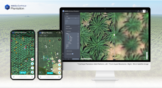
Dabeeo, a geospatial AI technology company, will officially launch its next-generation smart monitoring platform for forestry and plantation management, ‘Eartheye Plantation’, in July. The platform is based on Dabeeo’s achievement of commercializing 30-centimeter resolution satellite imagery for agricultural use—the first of its kind globally.
It features a dual structure with a web interface and a mobile app. The web version offers advanced AI analysis tools, including super-resolution technology that enhances satellite imagery to about 7.5 centimeters, high-density area detection, drone footage uploads with AI-based object recognition, and 3D modeling for digital twin simulations. These enable granular analyses such as solar exposure, flood risk prediction, and land suitability assessment.
The mobile app supports offline access and GPS-based navigation, allowing field workers to use standard smartphone cameras to classify palm fruit ripeness via AI, improving productivity and enabling performance-based evaluations.
Dabeeo aims to expand this platform as a smart forestry management standard throughout Southeast Asia
* Article source : https://www.koreaherald.com/article/10518686